Tuesday, October 7, 2008

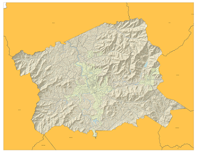
Latest Copy of My Bike Map


So here is the latest copy of my bike map. Still no idea what it will look like printed, but I am reasonably happy with it in the PNG format.

Sunday, September 28, 2008

Map Update


I found an index of the state road numbers along with their local names on the DOT website. The file came in an Excel file and after some data clean-up, I was able to join the DOT data with the NC Bike Routes Data. There are still some issues with labeling that I am trying to work out. The join did not carry over routes that had no local names. I am working to create an if/then statement to clean up the labels a little more, but have been running into problems selecting null values. Unfortunately, I've burned up a bit of time in trying to get the bike route labels right, so I am not sure what else I will be labeling yet.

Sunday, September 14, 2008

Map Format

So, for another class that I am in, I am tasked with creating a map of the Oakley Community in Asheville. The purpose of the map is to convey the location and size of the community in a manner that could easily be identified by someone who lives in Asheville (via major landmarks and/or streets). It will be displayed on a partial 8.5' X 11' piece of paper (probably 1/3 to 1/2 of the page). I have embedded the work that I have done so far in Google Maps (I will probably export the KML straight to a SHP file). I am wondering if anyone might have any ideas that they could leave me in the comments.


View Larger Map

Type Faces

I found the subject of font and type positioning to be somewhat troubling as I set to creating the map of Bike Paths in Buncombe County. I am struggling to find a way in which to cram as much information as would be necessary to create a sufficient map without crowding out the true purpose of the map, which is to convey the location (and possibly the suitability of area bike paths). I will try to post a picture of what my map is looking like tomorrow.

Tuesday, August 26, 2008

GIS 121 - LEAF International Map


Here is our first map of the semester. It shows the program locations of LEAF International. The map was compiled using Batchgeocode.com to create tab delimited text file of the program cities. The tab delimited text file was added into the Map Documented and a shapefile was created from the XY coordinates.

Tuesday, December 11, 2007

Final GPS Exam Study Guide

Identify the 3 segments of GPS
  • Control – ‘brain’ of the system
    • Controller monitors system and sends adjustments if necessary.
    • The DoD operates this segment from Falcon Air Force Base in Colorado Springs, Co.
    • Also, 4 monitoring and upload stations throughout the world.
  • Space
    • NAVigation Satellite Timing And Ranging
    • Fully operational system consists of at least 24 satellites
    • Constantly being ‘commissioned’ and ‘decommissioned’
    • 20,200km above earth, one revolution every 12 hours
  • User
    • GPS receivers on the ground
    • Civilian users outnumber military. Many applications.
    • Emergency Services, Public Safety, Recreation, Asset Management, Routing, Agriculture, Vehicle Tracking
List the acceptable number of satellites (SV's - space vehicles) for an accurate 3D position.
  • GPS position is calculated by Trilateration, measuring of the distance from at least three satellites to establish a position on earth.
    • Four for an accurate 3D postion.
  • Trigonometry requires three perfect measurement to define a point in three-dimensional space. However, the accuracy of a measurement based on three satellites may be diminished due to the non-synchronization of clocks in the GPS satellites and receivers.
List and explain sources of error in the GPS system
  • Selective Availability – turned of in May of 2000
  • Obstructions – buildings, vegetation
  • Multipath – GPS signals reflecting off objects
  • Atmospheric delay
    • Worse during the heat of the day
    • Worse when satellites low on the horizon
    • GPS works in all weather conditions
Explain why satellites are provide a good system for locating positions on the earth
  • Accurate position can be determined without having a direct line of sight between the known and unknown location.
  • Only need a clear view of the sky
  • Can determine accurate position almost anywhere at anytime on the earth.
Define trilateration
  • GPS position is calculated by Trilateration, measuring of the distance from at least three satellites to establish a position on earth.
    • Four for an accurate 3D postion.
  • Trigonometry requires three perfect measurement to define a point in three-dimensional space. However, the accuracy of a measurement based on three satellites may be diminished due to the non-synchronization of clocks in the GPS satellites and receivers.
Discuss how the distance from the satellite to the GPS receiver is determined.
  • Two factors involved in measuring the distance from a satellite.
  • The speed of the radio signal (the speed of light = 300,000 km/sec)
  • The time it takes the signal to reach the earth
  • Each GPS satellite transmits data that indicates its location and the current time.
  • All GPS satellites synchronize operations so that these repeating signals are transmitted at the same instant.
  • The distance to the GPS satellites can be determined by estimating the amount of time it takes for their signals to reach the receiver.
Describe the almanac and what it is used for
  • Set of parameters used to calculate the general location of each satellite.
  • The almanac specifies where each GPS satellite will be at any given moment in the near future.
  • Almanacs are used for planning the best time to collect GPS data and for quick acquisition of satellite positions by the receiver.
Define ephemeris information and what it is used for
  • The orbits of all GPS satellites are measured constantly by the DoD.
  • They determine satellite ranging and calculate the exact location of each satellite.
  • The adjusted measurements are transmitted from the DoD to the satellites
  • These minor corrections are then transmitted by the satellites as ephemeris information.
    • The ephemeris information is a data file that contains orbit information for one particular satellite.
    • Information used by the GPS receivers along with their internal almanac to establish precisely the position of a satellite.
Define autonomous GPS
  • GPS without some form of data processing to insure accuracy (not corrected in the field). It is accurate to +/- 10 M.
Describe differential GPS (SBAS, WAAS, Post-processing)
  • The precise measurement of the relative positions of two receivers tracking the same GPS signals.
  • One receiver places at a ‘base’ station over a know coordinate
  • Other receivers (rovers) use the corrected GPS information to eliminate error in their measurements
  • The ‘base’ station receives the same GPS signals as the roving receiver but instead of working like a normal GPS receiver it attacks the equations backwards.
  • Instead of using timing signals to calculate its position, it uses its known position to calculate timing.
  • It figures out what the travel time of the GPS signals should be, and compares it with what they actually are. The difference is an "error correction" factor.
  • The base receiver then transmits this error information to the roving receiver so it can use it to correct its measurements.
  • Wide Area Augmentation System
    • FAA’s strategic objective of a seamless satellite navigation system for civil aviation.
    • WAAS is based on a network of approximately 25 ground reference stations that covers a very large service area.
    • Signals from GPS satellites are received by wide area ground reference stations (WRSs).
    • Each of these precisely surveyed reference stations receive GPS signals and determine if any errors exist.
Define GPX
  • GPX, or GPS eXchange Format is an XML schema designed for transferring GPS data between software applications. It can be used to describe waypoints, tracks, and routes. The format is open and can be used without the need to pay licence fees.
What is a waypoint?
  • Waypoints are sets of coordinates that identify a point in physical space. For the purposes of terrestrial navigation, these coordinates usually include longitude and latitude, and sometimes altitude (particularly for air navigation). Waypoints have only become widespread for navigational use by the layman since the development of advanced navigational systems, such as the Global Positioning System (GPS) and certain other types of radio navigation. Waypoints located on the surface of the Earth are usually defined in two dimensions (e.g., longitude and latitude); those used in the Earth's atmosphere or in outer space are defined in at least three dimensions (four if time is one of the coordinates, as it might be for some waypoints outside the Earth).
Describe the critical software settings in Trimble TerraSync
  • PDOP = Position Dillution of Precision = 6 or higher (Measure of the geometry of the satellites in the sky)
  • Elevation Mask = 15 degrees or more (Satellites must be 15 degrees or more above the horizon or they are not used)
  • SNR = Signal to Noise Ration = Less than 39 (measure of the strength of the signal)
What is an .ssf file?
  • The native format for data files stored on Trimble GPS units. It stores attribute information beyond what a recreational GPS could store.
Describe what Trimble Pathfinder Office is used for.
  • Pathfinder Office is used to construct data dictionaries as well as to post-process data collected on Trimble units in the field. Pathfinder Office also aids in transferring files to and from the Trimble unit.
Describe several differences in a professional grade GPS like the Trimble GeoXT and a recreation grade GPS like the Garmin
  • Professional grade GPS devices allow the user to filter for accuracy.
  • Professional grade GPS devices allow data to be post processed.
  • Professional grade GPS devices have a higher accuracy rate.
  • Professional grade GPS devices allow for attributes to be stored during feature collection.
  • Professional grade GPS devices allow for data to be collected through the use of offsets.
  • Professional grade GPS devices allow for data to be collected through a greater variety of means.
  • Professional grade GPS devices can be loaded with different operating environments to meet the needs of the user.